Showing posts with label fortress. Show all posts

Monday, September 24, 2018

A Walk on the Xi'an City Wall - Part II

From the height of the Xi'an City Wall, I had a fairly good view of the surrounding area. Outside of the wall were quite a few skyscrapers and modern buildings. Contained within the wall were buildings typically of an older era and generally shorter. Some were rather dilapidated and in desperate need of repair. Others had received some renovation but still retained an older look.
Some of the buildings just inside the south wall were hostels. A sign here indicated that this building was the site of the Honglu Guesthouse, built during the Tang Dynasty to accommodate foreign guests and ethnic envoys. How interesting that the area has retained its original function! 

I liked how some of the newer buildings reflected aspects of the traditional architecture.

Buildings as seen from the North Wall.

Within the Northwest corner of the city is the Guangren Llama Temple. It was built in 1703 as a Palace Hotel for Dalai Lamas and Panchen Lamas on their way to pay homage in Capitol. It is the only Tibetan Buddhist temple within the Shaanxi province and the only worship temple for the Green Tara. The bronze roof of the Golden Worship Hall glistened in the late afternoon sunlight.

Guangren Llama Temple


Sunday, September 16, 2018

A Walk On Top of the City Wall - part 1

Archery tower on top of one of the ramparts
I hadn't intended to walk the city walls on this day, but after walking a bit along a park-like path alongside and looking up at the massive structure, I couldn't stay away. Its 40-foot (12 meters) high brick walls with protruding ramparts beckoned me.

Yongning - South Gate
I walked up the promenade leading to the South Gate, known as Nongning, meaning Eternal Peace. This was extremely close to the subway stop where I exited. Being one of the major tourist sites in the city, signs in English were present. I paid for the entrance ticket by having the QR code on my WeChat app scanned – much easier than using cash.
A wide and lengthy walk
Once on top of the walls, the width and legnth of the wall impressed me. It is between 40-46 feet in width. From my view at the South Gate, I couldn't even see to either corner. To make the trip around the 8.5 miles (13.7 km) wall more manageable, many people opt to rent a bike. Tandem bikes were quite popular. Riding at about medium speed, the whole circumnavigation would take between 1.5-2 hours. For those in a hurry, battery car can take smaller groups around.  Others like me chose to walk.
West Gate (Anding)
Built by the first emperor of the Ming Dynasty (1368-1644), the Xi'an City Wall was actually an enlargement of an original city wall made from rammed earth. The current structure is the largest and best-preserved city wall in China and one of the largest ancient military defensive systems worldwide. Around every 394 feet (120 meters), a rampart protruded from the wall. On top of each rampart was an archery sentry building. From here, soldiers could shoot arrows while being protected. The distance between each rampart was just within the range an arrow could be shot. Along the outer part of the wall were crenellations from where arrows could also be safely shot. The wall has a total of 5,948 of these battlements. Each gate had three gate towers. The outer one was used to raise and lower the suspension bridge. One opposite to it was used as a defensive outpost. An inner one was used as the main entrance to the city. Occasionally along the inner side of the wall, one could see very steep ramps that were once used for horses, but these were now blocked off. 

When I reached the West Gate (Anging) which means Harmony Peace, I had the option of descending. Seeing how clear the skies were and how pleasant the temperature was, I decided to push on.
Old and new structures side-by-side
Because I walked, I had plenty of opportunities to read the signs that were nicely posted in Mandarin and English. I also was able to take plenty of photos from different views.  Looking beyond the walls, one could see large contrasts in architecture, from run-down old structures to modern skyscrapers.
Wedding photos
A few bride and grooms took advantage of the beautiful weather and had some photos taken on this famous landmark. What a challenge the photographer must have had with the many bicyclists and pedestrians vying for the same space.
Northwest Watchtower
By the time I reached the northwest watchtower, the sun was already starting to get lower. I especially liked the roof of this building. Wanting to catch a taxi before it got dark, I pressed onward.
Bell from 1428
In the half of the wall that I walked, I saw a few bells. This bell near the Anding gate was from 1428 and was 5.6 feet (1.7 meters) high. Its rich tone once alerted people of the city.
North Gate at sunset

Just as I reached the North Gate (Anyuan), meaning Forever Harmony, the sun began to set. The flagposts, lamps, bell, and gate tower were now silhouetted against the warm glow of the sunset. It was a beautiful first trip to the Old City. With the address of my apartment written in Mandarin, a taxi driver successfully took me back to the concrete jungle of highrise apartments where I live about 25 minutes away. It was a good first adventure out.

Friday, February 26, 2016

From Ihwa Mural Village to Seoul's Fortress Wall

We continued to hike upwards through the Ihwa Mural Village. On one side of more stairs was this Black & White mural, contrasted beautifully against the blue sky.  

On the other side was Seoul's distinctive fortress wall, which was originally built in 1396. The wall spans 18.6 km and was built in 30 years. Parts of the wall have since been restored, while other sections were torn down to make way for modern construction. 

At the time it was built, the wall demarcated the outer limits of Seoul. From the many high-rises and skyscrapers now lining the horizon, it is quite apparent that the city has greatly expanded since then.


Wednesday, May 09, 2012

Hari Parbat Hill and Fort


Having spotted the fort on the hills surrounding the old city, I was glad we would have a chance to go a bit closer. We stopped at the ruins of a Mughal-style building below the fort. Developed by the Afghan governor Atta Mohammad Kahn, the fort was enlarged to its present size in the 19th century. From the vantage point at the ruined building, we had a panoramic view of the old city, with its corrugated tin roofs, mosque pagoda spires, still-bare trees, and Dal Lake. Falcons encircled high above, screeching as they searched for food. 


Saturday, April 02, 2011

Dundlod Fort


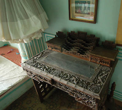
Although there was more we could have seen in Parsurampura, we headed to Mandawa, our destination for New Year’s Eve. Along the way we stopped at Dundlod to visit the fort. After waiting for a rather disorganized staff to take us inside, we toured the well-preserved interior. The main room was extremely spacious, framed with warm-yellow columns and filled with ornate European furniture and a collection of rare books. An old photo of the young handsome maharaja was on display on an antique table, accentuating the feeling of his presence. Also of note was an ornately carved wooden writing table and a whole room full of equestrian trophies.

Monday, March 28, 2011

Amber Fort, Jaipur


On our way to the Amber Fort, we stopped briefly at the pink Hawa Mahal “Palace of the Winds” building, and the Jal Mahal palace that seemingly floated in the middle of the lake. At the Amber Fort, colorfully painted elephants carried tourists up through the Suraj Pol gate and into the main courtyard. Some of the entrances such as the Ganesh Pol were beautifully restored, containing intricate floral patterns with the elephant god above the door. The Aram Bagh comprised of a geometric maze made out of carefully trimmed bushes. The splendid Sheesh Mahal room contained inlaid mirrors along with arabesque and floral designs. The bottom portion comprised of relief flowers in white marble, reminiscent of the Taj Mahal. Perched high up, we had a great (although misty) view of the Kesar Kyari Bagh ornamental garden below, surrounded by water.

Thursday, March 24, 2011

Mehrangarh Fort - Howdah Seats and Jharokas


Towering over the predominantly blue buildings of old Jodhpur is the Mehrangarh Fort. Although I had visited this fort before, its architecture, royal collection, and excellent guided tour made it worth a second view. The musicians were in their same spot, playing their traditional instruments. Passing through the elephant gate and past the sati hand impressions, I once again entered the palace grounds. The view of the “Blue City” below was diminished due to the light rains and overcast sky. The Howdah elephant seats once again impressed me with their details and skilled silver embossing. We saw the open palanquins that carried men and the covered ones that carried the royal women. Out in the courtyard, I once again took my share of photos of the jharokas (overhangs inspired by those of huts) shading the jali (lattice-like carved) windows.

Tuesday, January 18, 2011

Scales of Justice, Red Fort

On the itinerary of most visitors to Delhi is the Red Fort. One of its many buildings is the Khas Mahal, which contained the emperor's royal apartments with special rooms for private worship and for viewing. Inside its Robe Room is a wonderful marble jali screen window containing the scales of Justice. This motif is seen in many miniature paintings, made famous in Udaipur. Pigeons flew in and out through the broken portions of the jali emphasizing the delicate nature of the carving. It would be one of many beautifully carved windows on the trip that I'd admire.

Read more about the Red Fort on my previous trip to Delhi http://melissaenderle.blogspot.com/2009/04/red-fort-delhi.html

Monday, November 15, 2010

Sigiriya Rock Summit


About an hour and a half after beginning my ascent, I had arrived at the summit. The foundations of many buildings and pools remained, giving an idea of how extensive the place was. A stone bench looked quite tempting to sit down on, but a sign forbade it, saying it was a royal throne. From here, there was an uninterrupted view of the landscape below – and what a spectacular view it was! Past the heavily forested land with small lakes and then a mountain lay the city of Kandy. Just barely visible in another direction was the Gold Buddha statue of Dambulla.

After soaking in the surroundings and climbing up and down some of the buildings’ stairs, I headed back down. Along the way, I stopped by Cobra Hood Cave with a remnant of decorative fresco, a platform that was an audience throne, and through a natural arch. Much quicker than expected, I had reached the bottom and had plenty of time to swim and relax at the hotel.

Sunday, November 14, 2010

Sigiriya Lion

After turning around an incredibly windy corner and up more stairs, I arrived at a flat area. From here, I had a great view of the surrounding jungle as well as the gardens below. I had already climbed a lot of stairs, but I could see there were many more still to go. Against the base of the main rock were the two giant brick lion paws, remnants of the Lion from which gave the rock its name. At one time, the stairway led between the lion’s paws and up into its mouth, but the brick head fell off a long time ago, probably due to its support being constructed out of wooden beams. How imposing it must have once looked! A lot of steps were still to go. A few people motioned me to pass them in these narrow sections, making me particularly glad that I had gone up early before the crowds came.

Saturday, November 13, 2010

Sigiriya Mirror Wall

Back down the spiral staircase and continuing up the path towards the summit is the Mirror Wall. This highly polished (and protected by threat of large fine and/or imprisonment for those who touch or vandalize the surface) wall contains the graffiti inscriptions of visitors from between the 6th and 14th centuries who made their remarks about the rock & palace – and particularly the women frescoes, written in rather poetic and descriptive manners. A large number has been studied, deciphered, and published in a two-volume book. The markings also help document the evolution of the Sinhalese script and language. I’m glad someone had the patience and ability to decipher the ancient writings from modern defacing covering it.

Thursday, November 11, 2010

Sigiriya UNESCO site, Sri Lanka - History and Gardens

History and Introduction
After a wonderful early morning breakfast buffet at the hotel, I headed to the massive rock of Sigiriya that dominated the view from the hotel swimming pool. At 7:20 AM, the temperature was still pleasant. The sun was trying to peek up over the top of the flat-topped rock jutting 200 m over the flat land of north central Sri Lanka. We drove past a large pond filled with lotus flowers. At the entrance, I showed my UNESCO Cultural Round Ticket ($50) that was also good for Polonnurawa and Anuradhapura (which I wasn’t going to visit). Meaning Lion Rock, the unique geological mass is actually the hardened magma plug of an extinct volcano.

According to legend, the palace and gardens were built by King Kasyapa (AD 477-495) who fled here after killing his father and usurping the throne. After climbing up the 1,202 stairs to the summit, I can see how he would think that building on top of the summit would be a safe location. There is also evidence that points to the area serving as an ancient Buddhist monastery, particularly in the caves. It is quite apparent from the remaining structures and gardens that the city was planned and quite sophisticated, even including sub-surface hydraulic systems. After Kasyapa’s reign, the area reverted back into being a Buddhist monastery, lasting until about the 13th or 14th century.

Moat

Gardens
Passing through the well-preserved outer moat (which still has water), one first encounters the equally well-preserved symmetrical water gardens. How beautiful it must have looked at one time, with the fountains going and well tended gardens with flowers and shrubs – all against the majestic rock. Up past a series of stairs are the boulder gardens. Some of the boulders were used as bases of buildings.
Symmetrical water gardens

Wednesday, January 27, 2010

Trichy and Srirangam

Trichy
After eating breakfast at a local “hotel” that served Idlies, we drove to Trichy’s main site – the Rock Fort. Perching dramatically on a towering rock rising 83 m (272 ft) above the otherwise flat terrain is the fort, originally made by the Nayakas of neighboring Madurai who made Trichy their second capital in the 16th and 17th centuries. A Shiva temple was constructed at the same time. Very little of the original fortress remains. It played an important part in the Carnatic wars and also when the British came to the area. For those who ascend the 344 steps hewn out of rock, a panoramic view of the city and surround area awaits them. With our time short and a fair amount of driving today, we decided to skip the stair climbing and instead visit Srirangam.

Srirangam
Located 6 km north of Trichy is the Ranganathaswamy Temple at Srirangam, one of the most revered Vishnu shrines in South India. The island on which the temple complex is situated is formed by the Kaveri and Kollidam rivers, which, according to Hindu legend, symbolizes the transcendence of Vishnu. Unlike the temple complexes in other towns, this one seemed to engulf the entire city. In fact, it covers a total of 148 acres. My DK India guidebook used Srirangam as the diagram illustration for a South India temple town. While walking to the first gateway, we passed by a man who was making white chalk circles by thumping a loosely woven basket on the ground. I had seen these circles around the temple near my apartment in Chennai, particularly during special events. We reached the first gateway, topped by an immense and heavily carved gopura. It leads to the outermost courtyard, the latest of seven built between the 5th and 17th centuries. Although colorful, it lacked the profusion of sculptures I had normally associated with South Indian gopura. Completed in 1987, it largely replaced the original one that was mostly destroyed by the Delhi armies in 1313. Once inside, the bustle of a temple community was immediately sensed. Stalls sold various items for pujas including greens, coconuts, and fresh flower garlands. Other stalls sold food, souvenirs, or household items. Locals were going about their daily chores and shopping routines. Devotees with the telltale “V and Y” marks on their foreheads made their way towards the next series of gopura. Cotton candy sellers carried their goods on a stick, the bright pink sticking out in the crowd. We made our way up to the entrance of the fourth courtyard, which required those wishing to enter to remove their footwear. I would have loved to have stayed longer and explored, but it was felt that it would be prudent to move on in order to reach Ooty at a decent time. Perhaps I’ll come back and explore Srirangam properly.
Loading image
Click anywhere to cancel
Image unavailable

Sunday, January 10, 2010

Agra Fort


Another UNESCO World Heritage Site, the Agra Fort was built between 1565 and 1573 by the Emperor Akbar, who also built Fatehpur Sikri. The enormous complex is also built of red sandstone. The entryway was rather unique. Instead of a straight, flat drawbridge entrance, the Agra Fort employed a slight ascent and a 90° turn between the outer and inner gates. This made it impossible for elephants (used in attacks) to gain momentum. A deep moat, once containing water, surrounds the walled fort. Much has changed since Akbar built the fort. His grandson Shah Jahan (who built the Taj Mahal) tore down many buildings and replaced them with more opulent ones, including some made from white marble and inlaid with semi-precious stones. The British also made some additions in the 19th century, when they used some areas for barracks. From the marbled double-storeyed octagonal tower called the Sheesh Mahal, Shah Jahan was placed under house arrest by his son. From the tower one has a clear view of the Taj. It is here that Akbar spent his last 7 years of his life.

Sunday, January 03, 2010

More info on the Taj Mahal

I had a knowledgeable guide to accompany me for the day. This is what he told me about the Taj Mahal:

Mumtaz Mahal was near the end of her pregnancy when her husband asked her to accompany him in Buran-Pur, located about 900 km north of Agra. Although it was cooler up in Buran-Pur, Mumtaz originally declined the request even though it was cooler, concerned about traveling so late in her pregnancy. Upon Shah Jahan’s insistence, she relented and began the journey. While en route, she developed complications and delivered prematurely. Recognizing her grave state, Shah Jahan was immediately summoned. Grief-stricken and likely feeling guilty for convincing her to travel, Jahan expressed feelings of suicide. The 39-yr old Mumtaz told him not to kill himself, but instead asked him to promise her a few things. He was not to remarry. Jahan was also to erect a building of lasting love. Six months later, the architect was chosen, his design rendered with a brush and blood. Built to resemble the Islamic garden of paradise, the complex cost nearly 41 million rupees and 500 kg (1,102 lb) of gold. The Taj Mahal is 243 feet (74 m) high in the front and 253 feet (77 m) high in the back, behind which the Yumana River flows. The 144 ft (44 m) high double dome is capped with a Muslim finial symbol. On each corner of the Taj Mahal’s courtyard is a minaret, accentuating the perfect symmetry of the complex. Each is 131 feet (40 m) high and crowned by an open octagonal pavilion. My guide told me that the pillars actually were designed to lean outward slightly to ensure they would not topple onto the main building if they fell.

On the other side of the Yumana River were the foundations of the Black Taj building, intended by Shah Jahan to be his resting place. One of Jahan’s sons had that project stopped, saying that it would be way too expensive and would draw unnecessary, exorbitant costs from the emperor’s subjects. This son had Jahan placed under house arrest and into a tower of the Agra Fort, where he died at age 76 of old age.


For a virtual tour of the Taj Mahal, visit http://www.tracyanddale.50megs.com/India/Rajasthan/HTML/tajmahal.html

Thursday, December 31, 2009

Golconda Fort, Hyderabad


Although the light was fading, we went to our final destination, the Golconda Fort. Located about 11 km (6 miles) west of Hyderabad, it took a while to get through the traffic to reach the fort. Once the capital of the seven Qutb Shahhi kings who ruled from 1518 through the end of the 16th century before the court moved to Hyderabad, Golconda is quite large. We had a short time to explore the complex, so I decided to head up to the top, up its many stairs. The guidebook stated that the fort is one of the best-preserved forts in India, but I couldn’t really see this from the part I visited. You could still see portions of the wall, once 18 m (60 ft) high. On the way up we passed a Hindu temple that had a painting on a rock of the goddess Kalli. We also passed by some rainwater collection pools (now dilapidated and/or full of garbage), the mosque of Ibrahim Qutb Shah, and the three-storey Durbar Hall located on the top. From here I had a great view of Hyderabad and the setting sun. The walls of the building were scrawled with people’s names. Several people asked if they could take a family picture with me in it. Now I was the celebrity…


That evening the two eye doctors and I visited a pretty Hindu temple located high on a hill. To get up there, we ascended steps which were bordered on both sides by booths selling religious items, cheap Chinese trinkets, bangles, pearls, and more. Like all Hindu temples, we had to remove our shoes. Here we also had to turn in our cell phones, cameras, and other items. Ascending marble stairs, we joined the queue snaking around the temple. This temple seemed to be a mixture of Hindu temples found in various states; a gopuram seen in Tamil Nadu, a more plain Andhra style, A bit of Jain elements, and still another similar to what I saw in Orissa.