Wednesday, January 30, 2013

The Dragons of Jondeokjeong

Overlooking a smaller pond in the Secret Garden is Jondeokjeong, a hexagonal pavilion.  The oldest (1644) remaining in the area, it is noted for its double-layered roof. 

Here was one area where it really paid to look up. The ceiling of Jondeokjeong is centered with twin dragons playing with Cintamani, a symbol of upright royal authority.

Tuesday, January 29, 2013

Timbuktu's Manuscript Center, an Insurgent Victim

In 2009, I wrote about a welcomed development in Timbuktu, Mali, that was a long time coming. The precious ancient manuscripts (some dating back to the 1300's) I had seen several years earlier just sitting exposed on dusty shelves and cabinets had now finally received a proper building that would help preserve them. The Ahmed Baba Institute of Higher Learning and Islamic Research, with its collection of over 30,000 manuscripts, became an arson victim, burned by the Islamic fundamentalists as they were pushed out of Timbuktu by the French.  It is hoped that at least some of the manuscripts were removed to safe places ahead of time, just as they had been hidden or buried over the centuries in times of conflict. With only a small fraction digitized, it would truly be a loss if these historical and religious documents went up in smoke after surviving so long in a challenging environment.

Monday, January 28, 2013

Jondeokjeong Area, Secret Garden

Further away from the main palace buildings and deeper into the Secret Garden area of Changdeok Palace in Seoul is the area known as Jondeokjeong. Due to modifications made by the Japanese during occupation, its ponds are larger and consolidated. The tour guide I had on my first visit here was quick to point out that the large pond known as Gwallamji was in the shape of Korea.  (Considering that the Japanese changed the shape of this pond, I rather doubt that any resemblance to Korea' was not their intention). Slightly overhanging the pond was the pavilion Gwallamjeong. With the fall trees overhanging the still water, the scene was quite tranquil.

Up a small hill from the pond is a small square pavilion known as Seungjaejong. 

Saturday, January 26, 2013

Cathedral Rock, Sedona

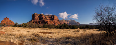
Our last site to visit in the Coconino National Forest afforded us a great view of one of Sedona's most famous landmarks - Cathedral Rock. It is considered by New Age adherents to be one of four areas in Sedona that has a power vortex that promotes relaxation. Although I can't attest to the presence of any vortex, I can say that the view off of the Red Rock Loop was magnificent. I particularly enjoyed the two views I presented here - which included the "flowing" red sandstone as seen above, as well as the Oak Creek in the photo below. Later in the day, the rocks had a warm glow, contrasting beautifully against the sapphire sky. The still waters below, reflecting the famous natural formation, added to the tranquility of the scene.


Thursday, January 24, 2013

Fay Canyon Trail, Sedona


Warmed by the sun overhead, we decided to hike the Fay Canyon Trail, located within the Coconino National Forest of Sedona. Rated as an easy trail with little change in elevation for most of the walk, it was a perfect hike for people of mixed ages to venture on, particularly with the slightly slippery snow. Part of the terracotta-colored path was already exposed, while other areas, particularly those shaded from the sun, were snow-covered. Snow clung to arid-looking bushes like balls of cotton. Away from the road, the silence of nature welcomed us. Along the way, we saw smooth stones piled up in a formation. In a few areas, visitors took advantage of the snow and created mini-snowmen. We ended our hike at the formation below, after which we would have needed to do more climbing up icy rocks. Note the mini-snowmen on the bottom right of the photo.

Monday, January 21, 2013

Those Changing Rocks

If the artist Claude Monet had visited the USA, the rocks of Sedona would have been a "must see." Having so carefully studying the changing light and appearance of the Rouen Cathedral over a series of over 30 canvasses, he would have been fascinated by how changeable the Sedona landscape was, depending on the time of day, height of the sun, and weather. The first afternoon we arrived in Sedona, the weather was crappy - snowy, windy, and overcast. The famous red rocks were partially obscured by the falling snow and were rather flat with little contrast.

The next morning, the sky was a brilliant clear blue. On the sides illuminated by the sunlight, the rocks looked as if they were sculpted, ranging from bright terra-cotta highlights to deep warm shadows on parts away from the sun's direction. Driving past the same rocks in the late afternoon, the play of lights and shadows painted a totally different scene. Although I am primarily a portrait artist, I would definitely feel compelled to study and paint these rocks if I stayed here longer. Such diverse beauty of God's creation.


Saturday, January 19, 2013

Built on a Firm Foundation

In the Bible book of Mark chapter 7, it talks about building one's house on a rock - a firm foundation, as an allegory for establishing a firm foundation for one's faith. I'm not sure if the sculptor Staude had this in mind when he conceived the Chapel of the Holy Cross or when the architect Strotz built the Catholic church in the beautiful red rocks of Sedona, but that's what came to mind for me when I saw it. Set amidst the Coconino National Forest (it seems a bit strange to me to see some forests in Arizona that are devoid of trees), the Chapel of the Holy Cross was completed in 1956, after decades of searching for the perfect spot. Just a year later, it was given the Award of Honor by the American Institute of Architects. It is now on the list of National Register of Historical Places.


A bright, clear day with the warmth of the sun, we walked up the steep curving road to get to the church. The massive cross, silhouetted against the panes of windows comprising nearly the entire front of the church interior, commanded its presence. What a view worshippers have, with the blue sky and red rock vistas! Lining the sides of the wall were rows of candles, lit in identical red jars. Although the lofty ceiling gave the church interior a vertical spaciousness, it didn't seem like the space would hold that many people for a service. Considered bold and audacious at the time of construction, it now is a major destination for visitors to the Sedona area, welcoming people of all faiths to enjoy its majesty.


Friday, January 18, 2013

Copper Mine, Arizona


On our way back from Tonto Natural Bridge, we stopped by a copper mine site. The rocky, barren-looking landscape had been transformed into a terraced seating of the Roman theatre in Dougga, Tunisia. Set high on a neighboring hill, we could see through the fence at the visitor's viewpoint some of the goings-on below, but at a very safe distance. Massive trucks hauling loads of dirt made their way across the terraces and down dusty road ramps. Because it was a holiday, not much other action was taking place. A tire from one of the mining vehicles was displayed in the visitor's area, but now was enclosed by a fence. To get a sense of scale, adults could easily stand in the inner part of the tire.
Copper mining is a huge industry in Arizona. Over 60% of America's copper supply comes from this state. In 2007, 750,000 metric tons of copper was mined in Arizona, amounting to $4.54 billion dollars.  Byproducts of copper mining include silver, gold, and molybdenum. Native Americans once used copper minerals as a pigment for decoration and early Spanish explorers found copper, but it wasn't until the arrival of the railroad that copper could be mined profitably.  

Wednesday, January 16, 2013

Roosevelt Dam and Bridge


Dedicated to then-President Theodore Roosevelt, the Roosevelt Dam was built from 1906-11. Located in the Salt River northeast of Phoenix, it was designed to help provide irrigation water and control flooding, the dam also generates hydroelectricity. This monumental project was one of the most significant factors contributing to the settlement of central Arizona. Originally at 280 feet in height and 723 feet in length, it  was considered the world's highest masonry dam. Its height was further increased to 357 feet following a massive reconstruction project completed in 1996. During the reconstruction process, the rubble masonry was encased with concrete, completely altering the appearance of the National Historic Landmark. No longer having the aesthetic character of the original dam, withdrawal of its historical landmark status was withdrawn in 1999.
Originally the traffic (Model T's at the time) drove over the top of the dam. Heavier and wider vehicles later necessitated a change.  The recent reconstruction project to the dam included the building of a bridge. Also named after Roosevelt, the bridge, spanning 1,080 feet, is the nation's longest two-lane, single-span, steel-arch bridge. 
The artificial lake formed by the dam was at one time the world's largest artificial reservoir. It felt a bit incongruous to see sailboats surrounded on both banks by desert lands. 

Monday, January 14, 2013

Still Life with Chest and Pottery

Here is a watercolor I just finished of an interior scene at a traditional home displayed in the Korean Folk village near Suwon, South Korea. With the subdued colors, I tried to convey a sense of tranquility.
See more of my artwork on my Flickr page.

Saturday, January 12, 2013

Red-Bellied Visitor

While eating lunch at the Tonto Natural Bridge, this cardinal paid us a visit. Rather close to us, it stayed on the fence several minutes, appearing rather comfortable with humans. It was all too eager to receive some bread crumbs from our picnic lunch, acting as if he'd done it before. Now only if it had sung its beautiful melodies!

Thursday, January 10, 2013

Tonto Natural Bridge


Located near Payson, Arizona, the Tonto Natural Bridge is the world's largest travertine bridge. As its name implies, this is a naturally-forming bridge, composed of a type of limestone deposited by mineral springs, particularly hot springs. The water is highly alkaline and contains particles of calcium carbonate in it, which settles and coats surfaces. Algae and vegetation roots help provide structural support for the aerial deposit of the travertine, much like how icicles form. The terraced Mammoth Hot Springs at Yellowstone is another, more famous example of a travertine formation.  The bridge is 183 feet high, standing over a 400 foot long tunnel that is 150 feet at its widest point. 
The park has several hiking trails and some picnic benches - perfect for our winter lunch!

 At one time the water gushed down to help form the bridge. Now it trickles down.
The icicles formed on the rock and dead tree were beautiful and helped complete a slightly other-worldly effect.

Monday, January 07, 2013

Tonto Cliff Dwellings

On one of our day trips from Apache Junction, Arizona, we visited the Tonto Cliff Dwellings (Tonto National Monument), located near the Roosevelt Dam. Situated between the northern Colorado Plateau and southern Sonoran Desert,   the Tonto Basin is home to a diverse selection of animals and plants and was farmed by ancient inhabitants. Lower elevations, are home to a variety of cactus-like plants including the famous saguaro, cholla, prickly pear, agave, and jojoba. In higher elevations, oak, juniper, pinyon, and ponderosa pines dot the hills. 

During the 13th-early 15th centuries, the Salado people (derived from the name of the Rio Salado - Salt River that flows through the area) made the area home, including the cliff dwellings that are preserved still today. It was fun walking through the remaining rooms, imagining what life in these cramped quarters must have been like. Blackened walls and ceilings (some of the original timbers and ceilings are still intact) still bear the signs of cooking and wood fires. Some hand/fingerprints from the Salado applying mud over the adobe can also be found. The visitor center has a nice, but small collection of weavings, polychrome pottery, yucca-woven sandals, and other artifacts from the site.


Saturday, January 05, 2013

Montezuma Well

After visiting Montezuma Castle, we drove an additional 11 miles to reach Montezuma Well. Formed from an ancient collapse of an immense underground cavern, many of the limestone sink's unique features lie below the surface. Over a million gallons of water flow into this pond-like structure on a daily basis through two underground springs. The water remains warm all year around at around 76°F. It contains very high levels of arsenic and carbon dioxide (nearly 600x the normal levels) and is home to five endemic species of small creatures found nowhere else, including a type of water scorpion and leech. 

The well was used for irrigation by the southern Sinagua tribe. Traces of the irrigation ditches are still present. Some pueblo dwellings can also also be found around the pond. Between 1125 and 1400, it is said that between 150-200 southern Sinagua lived in this area.

Thursday, January 03, 2013

Montezuma Castle


On our way to Sedona in Arizona, we stopped at a few sights, including Montezuma Castle National Monument. Built by a Native American group nicknamed the Sinagua, the 5-story, 20 room dwelling dates back to around the 1100's. Located about 100 feet above the valley, the shelter of the rock cliff alcove helped to preserve this structure. The site also has ruins of another structure known as Castle A, which was at one time 6 storys and had about 45 rooms. Hopi Indians trace their roots to the area and still return for some ceremonies. The area was discovered by settlers around 1860, who took many of the artifacts and other clues about the inhabitants. The name they attributed to the pueblo dwelling was incorrect, as it is not associated with the Aztec emperor, nor is it a castle. However, the misnomer stuck. Today's visitors can only view the dwellings from the valley floor. Despite this, the Montezuma Castle, one of America's best preserved cliff dwellings, it still is worth visiting.